
NWS: Tropical Storm Imelda Likely To Stay Offshore, Limited Impact Expected for Wilmington Area
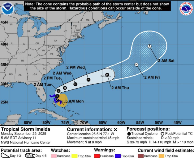
Residents of the Cape Fear region can breathe easier as meteorologists express high confidence that Tropical Storm Imelda will remain well offshore this week, bringing only minimal impacts to southeastern North Carolina and northeastern South Carolina.
According to the National Weather Service, Imelda is projected to track even farther offshore by Wednesday, keeping the storm's most dangerous elements away from the coast. While the system will pass to the south and southeast of the region, impacts on land are expected to be limited.
Maritime Hazards Remain Primary Concern
The greatest threat from Imelda will be felt across coastal waters, where waves generated by both Imelda and Tropical Storm Humberto are combining to create hazardous maritime conditions. Boaters and mariners are urged to exercise extreme caution through midweek.
Beachgoers should also remain vigilant, as rough surf and dangerous rip currents are expected along area beaches through Tuesday. A few waterspouts are possible Monday and Tuesday over nearshore waters.
Rain and Flooding Possible Through Tuesday
While rainfall projections have trended downward in recent forecasts, some flooding remains possible, particularly in low-lying and flood-prone areas of the coastal region through Tuesday.
The latest forecast calls for average rainfall amounts of one to two inches along the coast, with generally half an inch to one inch expected inland. However, isolated locations along the coast could see higher-end totals of three to four inches, though forecasters stress there's only a one-in-ten chance of these amounts occurring at any given location.
Conditions are expected to improve significantly during the second half of the week as Imelda moves farther out to sea.
Residents are encouraged to monitor local weather updates and avoid driving through flooded roadways. Those planning to visit area beaches should check surf conditions and follow lifeguard instructions.